Use of Ordnance Survey (OS) map detail: this is a non-commercial and publicly accessible website.
Thank you to OS for this service.
Routes shown and parking mentioned on this website are those used by the author. Readers heading for the summits are responsible for their own choices.
Playing the Game - Stones #70 - #78

Friday 07 April 2023
A High Five on a Good Friday
With the Easter holidays in full flow and the weather continuing to stay pleasant, Jen dropped us off at the Glensherrup car park in Glendevon and Scoot and I set off on the path over the reservoir in the direction of Ben Shee [BSh#45] making our way up over the 600m level as we aimed to place white-dot Stones on five summits on the List.
We were enjoying being out in the sunny, relatively warm weather, and made good time up onto the bealach where we had to depart from the Ben Shee path and turn left towards the higher targets to the west. And pretty soon we came to a junction in the path and I committed the cardinal sin of not consulting the map but making the decision to follow what
looked like the main track.
Well, it may have been the main track, but it was the wrong one for my plans, as it led us away from my first target, Cairnmorris Hill. By making this mistake at GR 939019 I gave us an extra few hundred metres of walking and set us on course to do the first three tops in a different order from the original plan – the “proper” route is marked as a dotted purple line on the map.
#70. However, this was a minor blip, and we now headed for Skythorn Hill [StH#70] (GR 927013), where we found a small cairn, but no sign of the yellow band Stone placed by Hugh a couple of years ago. A new one was now placed in the cairn along with a white-dot Stone and so it was off downhill to the lowest top of the day, and the realisation that there is no obvious path or track going in that direction.
#71. After a bit of a trudge over rough ground, we quite quickly identified the highest point on Middle Hill [MiH#71] (GR 929020), where it was matter of a couple of minutes to place a cane marker for the two Stones and decide that our best route to our next destination was to retrace our plodding steps back uphill to the track.
#72. From here, we were able to find the track which we should have originally been on and we were soon at the highest point on Cairnmorris Hill [CmH#72] (GR 934017), which at a height above sea level of 606m just fails to reach the 2000 ft requirement to be a “mountain”. Despite having a quad track passing right over the summit, there was no obvious feature to mark it, but there is now, as we left a marker cane and two agos400 Stones to rectify this situation – but for how long? We had a rest here to take in the superb view on this clear day over to the Trossachs and the Central Highlands, and of course a 360 degree panorama of the surrounding Ochils.

The Stones in the cairn on Skythorn Hill, with Andrew Gannel in the distance

Cane marking the Stones on Middle Hill with Burnfoot turbines in the distance

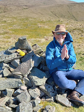
The cane and Stones on Cairnmorris Hill, with Tarmangie in the distance

Scoot places the white-dot Stone in the west cairn on Tarmangie, with the lower east one behind
#73. It was now time to make for our first Donald of the day, and once again we found ourselves going over some fairly rough ground as we had decided not to follow the path back to the track, but rather cut the corner and make for the gate at the foot of the track leading uphill to Tarmangie [Tmg#73] (GR 942014). From here we were both on familiar ground, and we soon reached the top, to be reminded that there are two cairns there, and after some exploring, we agreed that the more westerly one is the higher, so it was here that we placed the white-dot Stone, having, unsurpringly, not been able to find any trace of the Stone left by Scoot a couple of years ago. It was at this point that I discovered that my OS app which had been tracking our route was now misbehaving, and this explains why the map attached to this blog is not of the usual high quality!
#74. And so it was onwards to the last Donald to get a white-dot Stone, and our final summit for today before heading for the the finish. The walk over to Whitewisp [WwM#74] (GR 955014) is very straightforward and we were soon, surprise, surprise able to ascertain that the Stone previously left by Scoot is no longer in evidence, so having placed today’s last white-dot Stone, we headed for the pre-postioned car waiting for us at Castle Campbell. It’s all downhill from here, and the expedition is almost at an end – not. There is an obvious path leading from our summit onto the top of Saddle Hill, which saddley does not have the
prominence to make the List, and I persuaded Scoot that the best way to the finish was to head downhill from the bealach (saddle). I have certainly been up this way a couple of times in the past, but going down was not at all pleasant – steep and rough going, and not the best finish to the day. However, having headed for the sheep fank marked on the maps, we were able to follow the rough road leading down to the car park at Castle Campbell and it was a with a sense of satisfaction at a great walk and a job well done that we were able to head for home.

Today: 6 hrs 58 mins, 14.9 km and 655m. (Running totals: 184 hrs 21 mins, 515.4 km and over 20,254m)
The white-dot Stone about to join the cairn on Whitewisp - Tarmangie and Ben Cleuch in the distance
Thursday 20 April 2023
Been here before.
Almost three years ago, Lindsey and I placed yellow Stones on two of today’s summits, but I had to get the white-dot ones out, and another sunny Spring day was enough to entice me and Scott to go for a high level walk. The previous expedition is covered in Playing the Game – Stones #0.1 - #10 (Friday 5th June 2020).
Leaving from Menstrie, the pull up onto the top of Colsnaur [CnH#06] (GR 861993) was straightforward and it was a relief to get to there – just as puggled as I had been back in 2020. No sign of a yellow-band Stone could be found, and disappointingly, neither was there any evidence of the previously-placed white-dot one. I took the opportunity to leave a cane in the fence at the summit, and hopefully this will be able to replace the Stone.
Although the sun was splitting the sky, there were a few white clouds scudding along in the stiff, chilly north-easterly wind, and it was into the face of this that Scott and I had to set out on the next part of the route.


Cane replacing the white-dot Stone on Colsnaur
Following the obvious track, which has often led me to and from Blairdenon [BdM#61], it occurred to me that we were heading towards the Benominee Way, which didn’t even exist the last time I was here – it’s only become an official feature of agos400 in the past year or so – not a lot of people know that! About a kilometre from the top of Colsnaur, I began to look out for the stile which marks the junction with the Blairdenon track and the Benominee Way link leading to the Jerah Woodland Heritage Trail, since it is here that the Stones marking Colsnaur North Top [CnN#07] had been previously placed. It came as no surprise that we we were unable to locate either of them, and I once more prepared a cane to replace the white-dot Stone and placed it in the fence beside the stile. But lo – what was this – Scott had been exploring the area, and he was as surprised as I was when he extricated the yellow-band Stone from its grassy nest; so now, we have two canes and a Stone marking the track junction in the vicinity of the unmarked-on-any-map top of Colsnaur North Top.
It was now time to head off to the east, over the stile and then a dilapidated dyke. And out into the rough walking through Menstrie Moss, with no obvious tracks leading us to our next target, but in no time at all we had reached the cairn on Bengengie [BgH#08] (GR 869002), and yet again the elements seemed determined to try to blow us off the top.

A cane to replace the white-dot Stone missing from the stile at Colsnaur North Top

Scott found the original yellow Stone and cane - stile in the background
Namaste - and three Stones in the cairn on Bengengie
However, here there was to be a very pleasant surprise – instead of the yellow Stone having disappeared, in fact here it was shining in the cairn, which was not where I had originally left it! Some kind walker has obviously taken the time to transport it from its original location just under the summit and place it where it should probably have been in the first place. It was time for lunch, and so after a quick photo session, it was off the top and out of the wind for a welcome break.
The one and a half kilometre walk along the ridge to Craig Leith was slightly spoiled by the wind, but the sun and the great clear views of the surrounding hills made up for this. Unfortunately, it was back to normal at our destination, as I could find no trace of the yellow Stone, but the white-dot version was soon placed in the pile that gives Craig Leith, Mid Cairn [CLM#09] (GR 873988) its name.

The white-dot Stone in the Craig Leith Mid Cairn with Ben Cleuch in the distance
And so began the long, and for Scott, painful descent down to Balquarn reservoir - on this occasion quite full. It’s only fair to say that since the original track from Balquharn up to the reservoir has been allowed to become overgrown with gorse and is now impassable, the alternative route following the fence is very steep and difficult, which is not what you want at the end of a pleasant trip. However, we patiently made our way down onto the the back road, along which we were able to make good time back to Menstrie.
Today: 6 hrs 07 mins, 12.2 km and 700m. (Running totals: 190 hrs 28 mins, 527.6 km and over 20,954m)
The newest blog

#75. On our exiting the forest, the approach to the summit of Mellock Hill [MeH#75] (Gr 024061) was very obvious, and so we set off uphill through some pretty rough ground following the line of the double fence to our right. Towards the top of the hill, the going became a lot easier and we were soon able to stroll onto the featureless summit. As on quite a few past occasions, it seemed obvious here to use the fence as the site for the Stones and this we also marked with a cane.
#76. It was now decision time – were the conditions OK for us to go on and place a second Stone today? Over a relaxed lunch in the pleasant conditions, it was decided that we had enough energy to go for it and so we set off downhill in the direction of Carmodle Hill [CdH#76] (GR 029053).
Wednesday 07 June 2023
Two down today, just two more to go.
With only four tops still to get their white-dot Stone, the question today was how many can we get out today - one or two? Having picked up Hugh, who had previously placed a few yellow-band Stones, it wasn’t long before we were parking up at Littleriggs car park on the good old B934 Muckhart to Dunning road, and on a perfect day for walking we set off uphill on the forestry track in the direction of Innerdouny Hill [IdH#32](GR 032073 )
We soon reached the trig point at the top of Innerdouny, and were pleased to find that the yellow-band Stone was still there; having replaced the missing white-dot Stone, we retraced our steps downhill for a couple of hundred metres to the fence, which we followed to the left for the same distance until we found a very obvious forest ride leading to our left (GR 032075) and heading south west. This we followed for about a kilometre until we reached the edge of the forest. The OS app on the the phone was hugely useful on this leg!

Hugh and Stones on Innerdouny

The fence, cane and Stones on Mellock Hill
At the bottom, we found a handy gate and made our way up through the obvious signs that cattle have been grazing recently. On arrival at the summit there were no standout marker features, so once again a cane was planted beside the Stones; it will be interesting to see what the cows (and farmer) make of this “intrusion”!

So now it was time to make our way home, and we were both reluctant to simply retrace our steps. Good visibility and consultation of the 1:2500 OS map persuded us that we could find a way back into and through the forest, without having to climb back to the top of Innerdouny. It’s fair to say that the dry weather allowed us to do that, since we decided to attempt to cut a huge corner off the return trip by following a forest ride which had no obvious egress out onto the homeward track. We were fortunate. When we ran out of clear ground, we were able to negotiate a potentially marshy area of brashing left from previous harvesting, which did take us a while – but significantly less time than the alternative route would have taken.
Having regained the original forestry road, we now turned left and headed the one and a half kilometres back to the car.
Today: 5 hrs 59 mins, 14.0 km and 540m. (Running totals: 196 hrs 27 mins, 541.6 km and over 21,494m)
The cane and Stones on Carmodle - Innerdouny in the distance
Thursday 22 June 2023
The best laid plans ….
#77. A closer examination of the map, with only two tops still to reach, convinced me that trying to do them in one go was not likely to be a pleasant experience for me, and so I decided to take the opportunity of the good weather forecast to get a white-dot Stone onto Scadlaw [Scl#77] (GR 889035), where Gavin had previously deposited a yellow-band version almost two years ago.

I parked the car just off the Glendevon road and inside the gate on the Frandy road, and duly set off on my bike to cover the four kilometres along to the Upper Glendevon Reservoir. And got a rear tyre puncture after a kilometre!
Quickly dumping the bike in the weeds beside the road, I then tramped along the road as far as Backhills Farm, at which point, after taking water on board, I started what was intended to be the actual walking part of the excursion. Navigation amongst the wind turbines is pretty straightforward, and reaching the junction beside the windfarm substation I took the left turning in the direction of my target hill. As I descended the hill to the end of this track, I was already thinking that I had to come back up it on my return, but I could see my goal and I wasn’t turning back now.

The junction at the windfarm substation - hang a left.
After two or three hundred metres of negotiating a rough area of heather, I crossed the fence into Perthshire and had soon gained the summit of the hill, where I was pleased to find Gavin’s cane – but bemused to find no sign of the Stone he’d left beside it; I suspect this is not a top which is visited very often. I did notice, just a few metres from the top, a couple of fair sized boulders, and it is here that I have placed the white-dot Stone.
The views from here, and throughout the walk, are very interesting, looking at familiar hills from an unusual direction, and I particularly noted the neighbouring hill to the north, Core Hill, which is the final one on my List still to be climbed – hopefully in the near future.
I confess that the return journey was not as pleasant as I would have hoped, as I had become very aware of a sore spot on my right foot which was making walking very painful and slow.
Reaching the upper dam where my bike should have been waiting for me was particularly galling, but there was nothing else for it but to hirple back the four kilometres to the car, then drive back to retrieve my useless bike.
Note: a notice at the start of the Frandy road specifically warns that this is a private road for use only by authorised vehicles. There is, about a kilometre and a half along the road, a café with a car park which welcomes visitors. And on my return journey, I spoke to a couple who were parked in their car beside the upper dam who said they often drove up here to enjoy the environment; apparently “everyone does it”. Just saying.
Today: 6 hrs 59 mins, 19.97 km and 761m. (Running totals: 203 hrs 26 mins, 561.3 km and over 22,255m)

The white-dot Stone on Scadlaw - Core Hill, the final top on the List for another day, on the other side of the Glen
Sunday 6th August 2023
The final Stone
#78. Almost 40 months after laying the first “practice” Stone, it was time to get the last one in the Game of Stones placed, and many of the people who had supported this adventure were available and up for accompanying me to the top of Core Hill [CoH#78] (GR 886046).
For me, this was the culmination of a project that had involved countless hours of poring over maps, visiting websites and gleaning as much local knowledge of the Ochils as possible. I had walked for a total of almost 208 hours, hiked over 573 kilometres (356 miles, about the distance from Alloa to Cambridge) and climbed (and descended) over 22,725 metres (74,557 feet, equivalent to Ben Cleuch 31 times or Mount Everest – the height, not the conditions – two and a half times).
Having succeeded in keeping the car requirements for 12 humans and a dog down to three, there was ample room to park in the layby opposite the Blackford Distillery on the southbound carriageway of the A9, and we
set out due south on the track leading through the Glen of Kinpauch as far as the bealach before Glen Bee. This three kilometres was much more undulating than I remembered from previous visits, but it was the type one gravel which now covers most of that distance which was making the going very uncomfortable for me – and it seemed to be much further and much more uncomfortable on the return journey!
The last two Stones to be placed - in the mini cairn on Core Hill


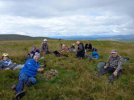
Hugh took this picture of family and friends on the 76th summit.
But before this, there was a summit to reach, and we were able to use a convenient handrail of a fence which led up over rough, tussocky terrain almost to the top of neighbouring Berry Hill, before we left it and headed south west to the top of our target hill, where we were able to add the last two Stones in the Game to the tiny cairn beside which we had a well deserved rest and a wee celebratory picnic.

We had been very lucky with the weather, and the clear visibility allowed us good views of the distant Donalds – Innerdownie, Tarmangie, Andrew Gannel, Ben Cleuch, with the wind turbines on Burnfoot Hill and Ben Buck very evident.
Narrowly avoiding an embarrassing descent in the wrong direction, we were soon on our way back to the fence, and with the rain just bypassing us, it was a happy band who were met at our base by experienced Gamer Scott, who had been unable to participate today due to an injury; silver lining for the rest of us, though – he had some classy champagne for the non drivers.
Today: 4 hrs 25 mins, 11.5 km and 471m. (Final total: 207 hrs 51 mins, 572.8 km and over 22,726m)